

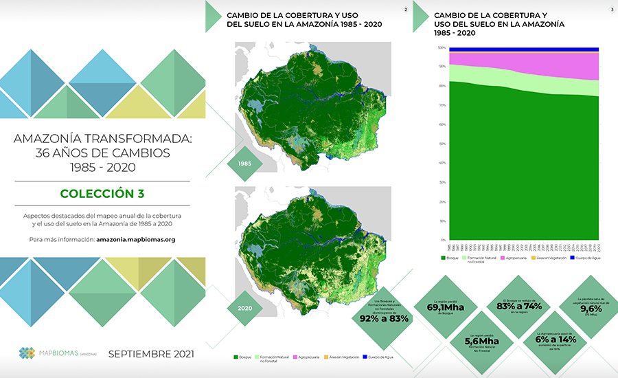
Between 1985 and 2020, the Amazon lost 52% of its glaciers and 74.6 million hectares of its natural vegetation cover, an area equivalent to the territory of Chile. In the same period, there was a 656% growth in mining, 130% in urban infrastructure, and 151% in agriculture and livestock.
MapBiomas Amazon is a mapping tool that allows monitoring land use changes throughout the Amazon and tracking pressures on its forests and natural ecosystems. The 3rd Collection of Annual Land Cover and Land Use Maps of the Amazon will be presented this Thursday, September 30 through the youtube channel youtube.com/raisg, at 9:00 a.m. Peru, Ecuador, and Colombia; 10:00 a.m. Bolivia and Venezuela; 11:00 a.m. Brazil.
There are more than 3 decades of history of Land Cover and Land Use in the Amazon that we present in this Collection 3.0, in annual maps from 1985 to 2020 with a resolution of 30 meters, and like all MapBiomas products will be available to the public from the MapBiomas Amazon platform https://amazonia.mapbiomas.org/. The platform offers the possibility of visualizing the maps at regional, national, and even local levels, identifying areas covered with forests, natural fields, mangroves, agricultural and livestock, and rivers, among other classes.
Between 1985 and 2020, the Amazon lost 52% of its glaciers and 74.6 million hectares of its natural vegetation cover, an area equivalent to the territory of Chile. In the same period, there was a 656% growth in mining, 130% in urban infrastructure, and 151% in agriculture and livestock. This unprecedented mapping incorporates the entire Amazon, from the Andes, passing through the Amazon plain and reaching the transitions with the Cerrado and Pantanal.
In 1985, only 6% of the Amazon had been converted to anthropogenic areas such as pastures, agriculture, mining, or urban areas. In 2020 this area almost tripled, reaching 15% of the entire region. The process varies greatly between countries, with only 1% in Suriname, Guyana, and French Guiana and at the other extreme 19% in Brazil.
Recent studies indicate that the loss of 20-25% of Amazon’s forest cover could mean the ‘tipping point’ for Amazon’s ecosystem services. If the current trend verified by MapBiomas continues, this tipping point could be reached in this decade.
For Beto Ricardo, general coordinator of RAISG, publishing MapBiomas Amazonía 1985-2020 Collection 3.0 is an important step towards the objective of contributing to the monitoring of the region with an integral vision that will allow us to consider political aspects of a region shared by eight countries, as well as socio-environmental aspects of great importance for its conservation. “Reconstructing the history of our Amazon by looking at the year-to-year changes of its natural coverages, identifying losses of such important coverages as glaciers and forests in general, helps us to build and propose more accurate conservation strategies,” said Beto Ricardo.
“The MapBiomas Amazon 3.0 Collection shows a profound and rapid anthropization underway in the region,” says Tasso Azevedo, general coordinator of MapBiomas, “in the MapBiomas mappings underway throughout South America this is a marked pattern. This database is invaluable for understanding the dynamics of natural resource use in the region, as well as contributing to climate modeling and the calculation of greenhouse gas emissions and removals from land-use change in the region,” he adds.
The mapping information is compatible for all countries in the region and provides information on the state of vegetation cover, as well as trends, in the unit to be worked on. It makes it possible to identify changes in land use in a given period (year, five-year period, decades, etc.) between 1985 and 2020.
Thus, with this third collection, generated by technicians and specialists from each of the countries that are part of the Amazon region, we seek to contribute to the knowledge of the current situation of the Amazon region in a comprehensive manner, also including new classes of use such as Mining and Urban Infrastructure. It also includes maps and data on the vectors of pressure on forests and other land uses such as mining concessions, oil fields, roads, and hydroelectric plants.
ABOUT MAPBIOMAS AMAZONIA
MapBiomas Amazonia is an initiative led by RAISG with support from MapBiomas Brazil. In 2019 the First Collection covering the period 2000 – 2017 was presented; in 2020 the Second Collection covering 1985 – 2018 and now the Third Collection covering 1985 – 2020. After intense work by the members of the Amazonian Network of Geo-referenced Socio-environmental Information (RAISG), and the technical collaboration of the MapBiomas Brazil team, Collection 3.0 is launched.
Initially, the land use mapping tool was developed by MapBiomas to be applied in Brazil, and had to be improved with the contribution of RAISG member organizations to adjust the results and analysis to the geography of each of the Amazonian countries. In this way, the existing knowledge at the local level has made it possible to improve the tool and refine the interpretation of the data. The information from each of the countries is perfectly compatible with that from the rest of the countries, allowing a comprehensive view of the Amazon region. Likewise, the method used has made it possible to standardize the biomes included in the analysis: the nine Amazonian countries share the Amazon Biome, while Peru, Ecuador and Bolivia also share the Andes Biome.
In particular, it was necessary to take into account the altitudinal variations specific to the Andean Amazon. Currently, the MapBiomas mapping tool includes 28 classes, ranging from Andean glaciers to the forest formations of the Amazon plains.
From the platform, it is possible to understand the dynamics of land use changes inside and outside an Indigenous Territory or a Protected Area, thanks to the fact that the platform not only offers maps but also statistics presented in tables and dynamic graphs with changes in use in the period required by the user, being freely accessible and downloadable.
ABOUT RAISG
RAISG is the Amazonian Network of Geo-referenced Socio-environmental Information, a consortium of civil society organizations from Amazonian countries oriented to the socio-environmental sustainability of the Amazon, with the support of international cooperation. RAISG generates and disseminates knowledge, statistical data and geospatial socio-environmental information of the Amazon, elaborated with common protocols for all countries in the region; it makes it possible to visualize the Amazon as a whole, as well as the threats and pressures it faces. RAISG is the result of the cooperation of eight civil society organizations working in six Amazonian countries: Bolivia, Brazil, Colombia, Ecuador, Peru and Venezuela.
ABOUT MAPBIOMAS
MapBiomas is a multi-institutional initiative that brings together universities, NGOs and technology companies that joined forces to contribute to the understanding of the transformations of the Brazilian territory based on the annual mapping of land cover and land use in Brazil. In August 2021, MapBiomas Collection 6 was published with land cover and land use maps of Brazil from 1985 to 2020.
The tool developed by MapBiomas for all its initiatives makes available information generated with a spatial resolution of 30 meters. The data is processed using automatic classification algorithms through information in the Google Earth Engine cloud.
Access the main highlights of this Collection here.
Watch the launch event here.